|
The
hydrologic modelling methods used in MIDUSS are well
recognized and very versatile.
You can
select from a choice of:
-
Five single event storms
(including custom
Malaysia storms),
-
Three
rainfall abstraction models,
and
-
Four
overland flow routing methods
This
combination provides a wide range of
modelling options. This allows you to examine
the sensitivity of results to the
choice of algorithm – a feature appreciated equally by
both professional engineers and teachers.
In addition to alternative methods for
generating runoff from a catchment there are capabilities
to add baseflow and to model a large, reasonably
homogeneous catchment as a ‘lumped area’ without having to
resort to unreasonable values for the overland routing
parameters.
You can
use either Metric or US units throughout MIDUSS.
If you
have generated hydrographs using another software product,
you can use the them in MIDUSS and takes advantage of the
MIDUSS design
capabilities you don't get with other packages.
The
MIDUSS Version 2 Reference manual includes
comprehensive engineering theory for all the available
hydrology models. In fact, the MIDUSS user manual
has been used as a supplementary text book at many
Universities and Colleges.
Learn more
about the MIDUSS hydrology features below.
Storm
Catchment
Lag & Route
Base flow
IUH Hydrograph
This lets you define a hydrograph based on a peak flow
value and time
to peak applied to an Instantaneous Unit Hydrograph.
STORM
The Storm command allows you to define a rainfall hyetograph
either of the synthetic, design type or a historic storm.
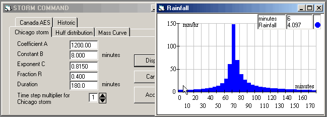
This window shows one of 5 available
options to specify a design storm.
| The available
Storm options
are: |
-
the Chicago hyetograph
-
the 4 Huff quartile design storms
-
a Mass rainfall distribution curve
-
the Canada Atmospheric Environment
Service storms
-
a user defined Historic storm
|
Storms may also be defined by importing a hyetograph
file in simple text format.
CATCHMENT
The Catchment command lets you define a single
sub-catchment and computes the total overland flow
hydrograph for the currently defined storm. You can,
of course, combine an unlimited number of catchments
within a drainage network.
The roughness, degree of imperviousness
and surface slope of both the pervious and impervious
fraction are defined in this command. The effective
rainfall on these two fractions is computed and stored for
future use.
The runoff hydrographs from the pervious
and impervious areas are computed separately and added to give the
total runoff.
MIDUSS offers a choice between three different models for
estimating infiltration and rainfall losses and four alternative methods
for routing the overland flow.
|
Rainfall losses using: |
|
Route the flow using: |
- SCS CN
- Horton
- Green & Ampt
|
|
- Triangular SCS
- Rectagular
- SWMM method
- Linear reservoir
|
Rainfall
loss can also be estimated using the simple runoff
coefficient which is converted to a corresponding SCS CN
for the current storm depth. All rainfall loss
methods can be used with any of the flow routing
algorithmns with the exception of the SWMM runoff method*.
The
Triangular SCS is a dynamic triangular response
function in which time of concentration varies with the
intensity of the effective rainfall
The
Rectangular response function varies dynamically in
the same manner as the triangular response.
The SWMM
RUNOFF algorithm uses a stage-discharge relation based
on the Manning equation coupled with a non-linear
reservoir. *Use of the SWMM routing method limits
infiltration methods to either Horton or Green & Ampt.
The
Linear reservoir response function is defined by the
impulse response of a single linear reservoir. Use
of this method is similar to the OTTHYMO procedure.
MIDUSS lets you compare methods and to
examine the sensitivity of the resulting runoff hydrograph
to the methods used. This flexibility means, however, that
you must exercise some care and consistency in the
selection of procedures and parameter values for a
particular application.
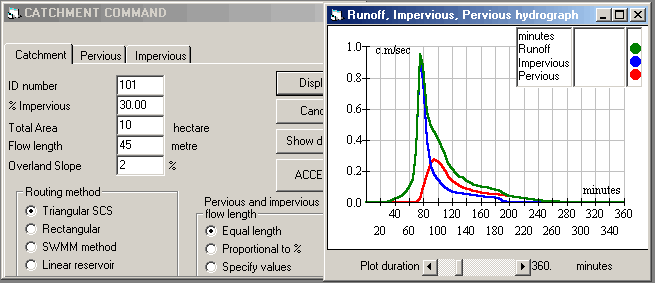
This window shows the first of many
options in the catchment command. The runoff is computed
as the sum of the direct runoff hydrographs from the
pervious and impervious fractions. These can be specified
and computed from the appropriate tabs on this form.
LAG and ROUTE
This command helps you model the runoff from a very
large sub-catchment without having to resort to
specifying unrealistically long overland flow lengths.
The command computes the lag time in
minutes of a hypothetical linear channel and linear
reservoir through which the runoff hydrograph is routed.
Typically this results in a smaller, delayed runoff peak
flow.
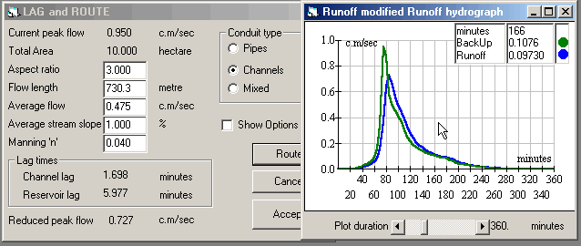
Lag and Route is intended to simulate a very large
catchment (>30 ha or 75 acres) using a hypothetical
linear reservoir in series with a linear channel at the
downstream end of the catchment. The lag of the two
components is roughly 2/3 of the total travel time in the
conduits from the most remote point in the drainage
network to the outflow. The linear reservoir lag is
roughly 2/3 of the total. These fractions are defined by
an empirical curve built in to the program and which can be
edited.
The travel time is dependant on the type of
conduit, the slope, roughness and average flow. The
reservoir and channel lags are computed and displayed but
you can modify these as a special option.
The
modified peak flow is shown on the form along with a
graphical and tabular display.
BASE FLOW
This command lets you specify a constant positive value of
base flow to be added to the current inflow hydrograph.
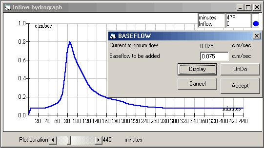
The direct runoff hydrograph computed by the Catchment
command does not include any baseflow. This command lets
you add an estimated baseflow to the current Inflow
hydrograph. If some baseflow has been added previously, a
negative value can be used as long as it does not result
in a negative ordinate in the inflow hydrograph.
IUH HYDROGRAPH
This command provides a simple way to create an Inflow
hydrograph with a user-specified peak
flow and time to peak (or duration) with a shape defined
by a file containing the coordinates of a
pre-defined Instantaneous Unit Hydrograph. A file
containing the SCS IUH curve is included with MIDUSS and
you can easily prepare similar files to describe other IUH
shapes.
You can enter a desired peak flow value and also
specify either the time to peak in minutes or the
duration in minutes.

|